

Click the Map Above to Open the Interactive Route, Cycle Parking and Access Map
Thanks to the efforts of Nic Siddle, one of our campaign members, and a group of indefatigable volunteers, including Eileen Morgan, our very own Inclusive Cycling Officer acting as consultant, the Campaign is carrying out ground-breaking work mapping out barriers along the Millennium Greenway and other local Sustrans routes.
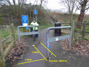
The intention is to highlight various barriers and other features that prevent those that require electric mobility scooters or adapted bikes as mobility aids from fully enjoying off road routes developed by UK cycling charity Sustrans.
The map also displays all types of local cycle tracks and routes, including shared use paths. All cycle parking locations around the city have also been included, making it easy to find the cycle parking facility nearest to your destination.
About the Interactive Online Map
 The map takes the form of an interactive Google Map with additional layers added for each type of feature being mapped.
The level of detail on the map is truly impressive – complete with photos, grid references, measurements, etc. We believe there can’t be many, if any, areas of the country with such a detailed level of mapping, particularly with a focus on accessibility.
Displaying and Hiding Map Features
Use the tick-boxes on the left side of the displayed map in order to hide or reveal the features that the Campaign has added to the map, including:
- Barriers & Access
- Bike Parking
- Existing Cycle Paths & Lanes
- ‘Aspirational’ Paths
- Amenities
- Hazardous Junctions
Note that the satellite terrain background can be turned on and off using the square toggle button at the very bottom left corner of the features panel.
Chester Cycle Map User Guide
Further information about the use of the map is available in the accompanying user guide which can be accessed using the link below. This includes detail about the aims of the project, the conventions used in order to portray different types of path surface, etc.
Want to Help?
Volunteers who would like to be involved in this important and inclusive initiative would be very welcome. Using the link below, please contact the Campaign with your details and how you might be able to help. We will then put you in touch with Nic.
Contact Us About the Mapping Project
Raising the Bar Initiative
 The Campaign is involved with ‘Raising the Bar’, a new fundraising focus for national charity Sustrans, as it seeks to improve the accessibility of its shared use network across the UK. Eileen Morgan, the Campaign’s appointed ‘Inclusive Cycling Officer’ has been playing a key role in raising awareness of the needs of those who make use of adapted bikes and/or mobility scooters to enjoy the cyclepaths belonging to Sustrans. You can find out more about Eileen’s involvement by following the link below:
York Cycle Campaign, where they claim they have a problem with bike theft, have extended their version of our map overlay with information about CCTV coverage of bike storage options. Sounds like a lot of effort but could be do-able if we all took on a piece of the work.
Very useful resource. Regarding RAISING THE BAR, is the Campaign having any success in getting those A-frame restrictions removed from the River Dee path in Flintshire? They are a pain for those on a regular bike and impossible for those in a wheelchair or on almost any type of non-standard bike.
This is really useful. Thank you so much. Matty